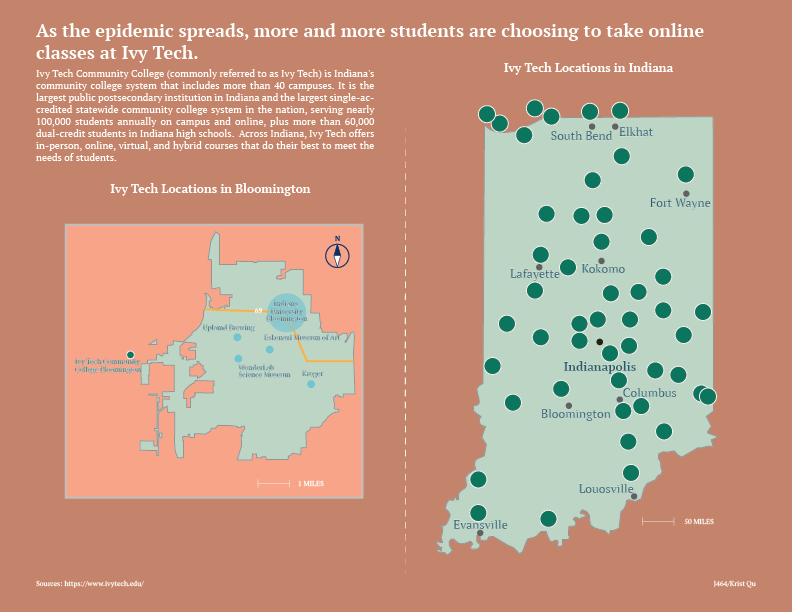
I did think about many topics before I made the map project, but I finally decided to make a map of the distribution of IVY TECH in Indiana. This is because I took an online class at IVY TECH last semester at my friend’s suggestion and because more and more IU students were willing to take classes at IVY TECH during the epidemic. So I decided to make a map about IVY TECH to briefly introduce the location of it.
Ivy Community College, Indiana’s community college system, which includes more than 40 campuses, is the largest public postsecondary institution in the state and the largest single-accredited statewide community college system in the nation. It’s mostly located in Indiana, so I wanted to make a map of Indiana first to mark the distribution of IVY TECH. I had no prior idea that IVY was so densely distributed in Indiana and was very surprised indeed. After drawing the outline of Indiana with the pen tool, I started making the IVY logo in Illustrator. IVY’s logo isn’t that complicated, like a sapling. The lines are all straight, so it’s done with a pen tool. Then I have to make the background color, the sampling and the circle as a group. In the Indiana map I emphasize Indianapolis since it is the capital of Indiana.
Then I decided to make a map of IVY in Bloomington. This will be more detailed and cover more detail than the entire Indiana map. I’ve interspersed iconic buildings and interstate highways to help the reader better understand the orientation. Finally, I’ve made a little compass logo to tell the reader north and south.
From a design standpoint, I’m very mindful of the color scheme this time around. I didn’t want my map to be so saturated that it made the readability low. I chose the Morandi color card so that the map looks very harmonious, like a complete whole. Then I chose a light green to fill out the Indiana and Bloomington map because to me Indiana looks like it’s in a forest, and the greenery is done wonderfully. On the outside of the Bloomington map I chose to make a lighter border to create a sense of space visually.