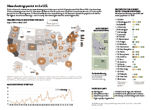
For my project I decided to map mass shootings across the U.S. Mass shootings have been an issue in the U.S. for decades, but this month there were two mass shootings just six days a part, which is why the topic was at the front of my mind. I thought the key factors to cover were where the shootings have happened, how different states compare in mass shooting frequency, gun laws across states and how shootings have increased over time.
My primary map combines a choropleth and proportional symbols map to show where mass shootings have occurred over the last 55 years and how many gun laws are enacted in each state. I thought it would be interesting to show both on one map because I think most people, myself included, would have expected mass shootings to be more prevalent in states with fewer gun laws. I also decided that accounting for population would be important to include – which led to the creation of my secondary graphic that looks at the states with the highest mass shooting rates. I was surprised by some of the states that were still in the top 50% of shooting rates, which is why I decided to add an indicator showing which political party controls the legislature and again the gun laws per state. I also wanted to include a locator map for the most recent mass shooting in Boulder, Colorado since that is what gives the package its newsworthy element. Finally, I chose to include a line chart to show how the frequency of mass shootings has increased over time.
My main source for the package was The Violence Project because they track mass shootings and have an extensive database and solid methodology. Their data base went further back than others that I saw, but I thought their reasoning for going all the way back to 1966 was logical. I also relied heavily on the Washington Post for information on the gun laws in each state. When I first decided to include gun laws, most of the sources I found were lobbying pro or against stricter gun laws, whereas the Washington Post was simply stating what exists where. I also used a handful of other sources, but only for small supporting details.
Stylistically I used my established style guide for font choices and graph layout. In this project I did rely heavily on color to convey the data, so I spent a lot of time on the color scheme. I needed to use a lot of different colors but did not want them to distract from the information. I also spent more time than usual on the internal layout of the package. I had a lot of data and several different pieces, so I did not want the layout to become too tight or hectic. This was one of the harder pieces that I have designed because there were so many different pieces to put together into one cohesive package. But in the end, I was happy with how the project turned out.